
B.R.A Methodology
B.R.A Methodology
The Biodiversity Resilience Assets (B.R.A.) Generation Methodology is a structured, science-based approach to evaluating and preserving ecosystems. Combining advanced technology, ground research, and robust monitoring, this process ensures accurate assessments and meaningful support for biodiversity and local communities. Here’s how the methodology unfolds:


Step 1
Preliminary Assessment
PlanetaryX uses existing datasets to conduct rapid, cost-effective evaluations of proposed zones for Biodiversity Resilience Asset issuance. This process generates conservative estimates of potential B.R.A.s by measuring above-ground biomass and extrapolating related variables.
Step 2
Geotechnical Studies
Our team carefully delineates each study area, checking for overlaps with indigenous or protected zones. We analyze land use, cover, vegetation, and soil carbon stocks by combining public datasets with satellite imagery from PlanetaryX partners. This includes calculating above-ground and below-ground biomass, along with litter and deadwood measurements.

n

n
Step 3
Field Campaign
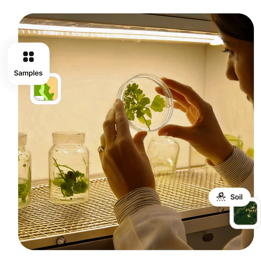
Following the preliminary steps, we establish sampling plots where ground teams conduct thorough field research. This includes inventorying flora and fauna, studying soil and water, and assessing local community conditions. Data collection occurs through PlanetaryX's proprietary app(certified by Bureau Veritas in ISO 27001 e 27018) and is cross-checked against previous study results.
Step 4
Lab Assessments
Laboratory testing includes spectroscopic analysis and physical-chemical assessments of field samples. These tests provide accurate measurements of biomass while assessing soil quality, microbial activity, and species health and diversity. To determine the final B.R.A. count, we apply a biodiversity index to the measured carbon stock.
Step 5
Further Monitoring
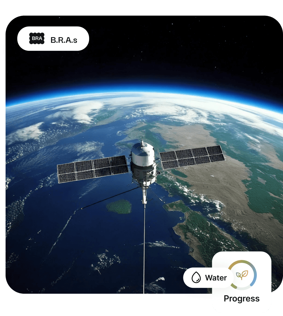
The issued B.R.A.s represent supporting ecosystem services—including nutrient cycling, soil formation, and biodiversity habitat provision—using carbon biomass as a proxy. After certification, we use remote sensing to track developments in surveyed areas and prepare for future assessments.


Areas already protected
Live B.R.A. Projects
Lorem ipsum lorem
Connect with Our Team
Meet the passionate individuals driving biodiversity resilience and innovation at PLX.
About
Biodiversity Resilience Assets
© 2024 PX. All rights reserved.
Connect with Our Team
Meet the passionate individuals driving biodiversity resilience and innovation at PLX.
Use Cases
Regenerative Agriculture
Primary Rainforest
Connect with Our Team
Meet the passionate individuals driving biodiversity resilience and innovation at PLX.
About
Biodiversity Resilience Assets
© 2024 PX. All rights reserved.
Step 1
Preliminary Assessment
PlanetaryX uses existing datasets to conduct rapid, cost-effective evaluations of proposed zones for Biodiversity Resilience Asset issuance. This process generates conservative estimates of potential B.R.A.s by measuring above-ground biomass and extrapolating related variables.
Step 2
Geotechnical Studies
Our team carefully delineates each study area, checking for overlaps with indigenous or protected zones. We analyze land use, cover, vegetation, and soil carbon stocks by combining public datasets with satellite imagery from PlanetaryX partners. This includes calculating above-ground and below-ground biomass, along with litter and deadwood measurements.
Step 3
Field Campaign
Following the preliminary steps, we establish sampling plots where ground teams conduct thorough field research. This includes inventorying flora and fauna, studying soil and water, and assessing local community conditions. Data collection occurs through PlanetaryX's proprietary app and is cross-checked against previous study results.
Step 4
Lab Assessments
Laboratory testing includes spectroscopic analysis and physical-chemical assessments of field samples. These tests provide accurate measurements of biomass while assessing soil quality, microbial activity, and species health and diversity. To determine the final B.R.A. count, we apply a biodiversity index to the measured carbon stock.

B.R.A.s
Progress
Water
Step 5
Further Monitoring
The issued B.R.A.s represent supporting ecosystem services—including nutrient cycling, soil formation, and biodiversity habitat provision—using carbon biomass as a proxy. After certification, we use remote sensing to track developments in surveyed areas and prepare for future assessments.


Areas already protected
Live B.R.A. Projects
Lorem ipsum lorem

Forest Formation
Floodable Forest
Grassland
Pasture
Forest Formation
Floodable Forest
Grassland
Pasture
n
335
Floristic - Total Species
Flora
Step 1
Preliminary Assessment
PlanetaryX uses existing datasets to conduct rapid, cost-effective evaluations of proposed zones for Biodiversity Resilience Asset issuance. This process generates conservative estimates of potential B.R.A.s by measuring above-ground biomass and extrapolating related variables.
Step 2
Geotechnical Studies
Our team carefully delineates each study area, checking for overlaps with indigenous or protected zones. We analyze land use, cover, vegetation, and soil carbon stocks by combining public datasets with satellite imagery from PlanetaryX partners. This includes calculating above-ground and below-ground biomass, along with litter and deadwood measurements.
Step 3
Field Campaign
Following the preliminary steps, we establish sampling plots where ground teams conduct thorough field research. This includes inventorying flora and fauna, studying soil and water, and assessing local community conditions. Data collection occurs through PlanetaryX's proprietary app(certified by Bureau Veritas in ISO 27001 e 27018) and is cross-checked against previous study results.
Step 4
Lab Assessments
Laboratory testing includes spectroscopic analysis and physical-chemical assessments of field samples. These tests provide accurate measurements of biomass while assessing soil quality, microbial activity, and species health and diversity. To determine the final B.R.A. count, we apply a biodiversity index to the measured carbon stock.
Step 5
Further Monitoring
The issued B.R.A.s represent supporting ecosystem services—including nutrient cycling, soil formation, and biodiversity habitat provision—using carbon biomass as a proxy. After certification, we use remote sensing to track developments in surveyed areas and prepare for future assessments.
Areas already protected
Live B.R.A. Projects
Lorem ipsum lorem